The project is located approximately 350 km northeast of Perth and 110 km north-northwest of the regional township of Southern Cross.
The Mt Jackson Project is located at the convergence of the Southern Cross Greenstone Belt, the major crustal-scale Youanmi Shear Zone and the regional scale Koolyanobbing Shear Zone at the northern end of the belt. The Southern Cross Greenstone Belt is a well-endowed mineral province and has collectively produced >15Moz of historical gold.

Location of the Mount Jackson Project
The Mt Jackson Project was initially targeted on a 5km long magnetic anomaly in an area of shallow sand cover that was interpreted to be the northern extension of the Southern Cross Greenstone Belt. Earlier wide-spaced soil sampling confirmed the likely presence of mafic and/or ultramafic rocks with several low-level gold anomalies identified.
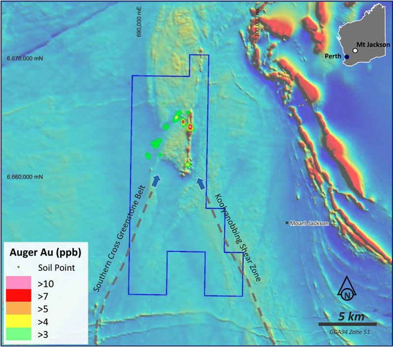
Figure 1. Mt Jackson project regional aeromagnetics with gold soil sampling results
Falcon completed a number of comprehensive soil sampling programs, including an additional 818 samples collected on a 100m x 100m spacing.
These new results have further refined several of the gold targets with the highlight being a 1km long north-south trending target >3ppb Au with a peak value of 17.5ppb Au that is coincident with the interpreted Southern Cross Greenstone Belt. In addition to this, a 7km long northeast-southwest anomaly has been confirmed in a demagnetised zone that is interpreted to be associated with the Youanmi Shear Zone and is open to the south. This anomaly is >2ppb Au and is a more subtle response given the extensive aeolian cover interpreted to be developed in this location on the eastern side of a salt lake system.
In addition, three zones with coincident nickel, copper, platinum and palladium anomalism along the interpreted Southern Cross Greenstone Belt have been prioritised. Moving Loop Electromagnetic (MLEM) surveying is planned to test for nickel sulphide mineralisation. Drill planning for these targets will be dependent on the outcomes of the MLEM surveys.
Although the soil sampling programs were designed to test largely for gold and base metals, several anomalous lithium zones were also detected. The sampling and assaying methodology is not considered optimal for lithium exploration and specific orientation programs will be required if encouraging results are obtained from the current work programs. The analytical method used for this was a 0.5g Aqua Regia digest of -50 µm material. This is considered a partial digest so can report lower values than more aggressive methods such as a four-acid digest or sodium-peroxide fusion. Although the level of lithium anomalism is low, they have formed discrete anomalies relative to the background and these zones are considered targets requiring further soil sampling and potential aircore drilling.

Plan map of Mt Jackson showing the Au soil sampling results

Plan map of Mt Jackson showing Ni and Cu soil sampling results

Plan map of Mt Jackson showing Li soil sampling results